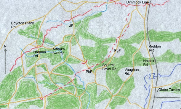
| This map (based on the
one on page 250 of Richard Sommers's Richmond
Redeemed) shows the
terrain and roads west of Globe Tavern and
approaching the Petersburg lines. The
fortifications are as of the Federal attack in
September. The Federal lines are the dark blue in
the southeast corner of the map. The main
Petersburg lines are just on the north edge of
the map. The Boydton line is shown leading to the
southwest. In front of the Boydton line is the
so-called "Squirrel Level Road line."
This was a covering line of entrenchments whose
purpose was really to serve as a
"breakwater" should any Federal force
advance against the Boydton line. During the September fighting, a Federal force consisting of
two divisions of V Corps and two divisions of IX
Corps, supported by one division of II Corps
attempted to breach the Boydton line and cut that
vital artery into Petersburg. This led to a
series of fights at Fort Archer, Peebles farm
("PbF"), Jones Farm ("JF"),
Pegram's Farm ("PgF") and near where
the Harman Road crosses the Boydton line.
Although unable to crack the Boydton line, the
Federals did take the Squirrel Level Road line
and extended their lines into this area. The
eventual final breakthrough of the Petersburg lines would
be launched from ground taken in this operation.
For a map that details that action of the siege, click
here.
During the winter of
1864-65, the extensive woods seen here were
almost entirely cut away, either to clear fields
of fire in front of entrenchments, or for
construction and firewood.
|