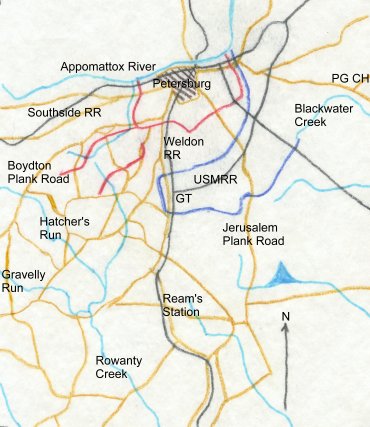
 This map is based on the one on
page 234 of Richard Sommers's Richmond
Redeemed, and shows the
road network and state of the entrenchment lines
in late September, 1864, at the time of the
Peebles Farm battle. Because of the crowded
nature of the map it was only possible to label
the major roads. This map is based on the one on
page 234 of Richard Sommers's Richmond
Redeemed, and shows the
road network and state of the entrenchment lines
in late September, 1864, at the time of the
Peebles Farm battle. Because of the crowded
nature of the map it was only possible to label
the major roads.
The red
lines show the Confederate works as of late
September; the dark blue line shows the Union
works. Note that the Yankees have been forced to
build a second "reverse line" to
protect their rear areas. Similar sets of works
existed around City Point and at other detached
strong points in the vicinity. Note also how the
Federal engineers have tied this reverse line
into Blackwater Creek. The notation
"USMRR" refers to the "US Military
Railroad," a functioning rail line which the
Federals built behind their entrenchments to
facilitate lateral moverment in that part of the
lines that was devoid of good roads.
The red
line enclosing Petersburg is the original Dimmock
Line for the most part; the "tail"
running off to the southwest covering the Boydton
Plank Road is a new line, still being
constructed. The detached line in front of it is
the Squirrel Level Road Line, which was set up to
cover the construction of the Boydton Line.
During the Peebles Farm operation (also
known as Grant's Fifth Offensive) the Union troops sallied forth
from the Globe Tavern ("GT") vicinity,
breached the Squirrel Level Road Line, and
threatened but were unable to take the Boydton
Line.
|