The black letter "J" marks the approximate location of the Battle of the Jerusalem Plank Road in mid-June, 1864; the black letter "G" marks the approximate location of the Globe Tavern fight in August, 1864. The Battle of Reams Station took place off the map to the south, along the Weldon Railroad. The several fights along Hatcher's Run and the Boydton Plank Road took place off the map to the west. The Battle of Peeble's Farm in October, 1864, took place (very approximately) at the black letter "P" on the map. |
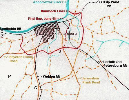 This map,
which is based on Map 138d of the West Point Atlas, shows
the immediate environs of Petersburg and the associated
road and rail network. During the initial assaults from
June 15-18, the Army of the Potomac attacked exclusively
against the eastern face of the Dimmock Line, forcing the
Confederates ultimately to fall back to the dotted red
line much closer to the city.
This map,
which is based on Map 138d of the West Point Atlas, shows
the immediate environs of Petersburg and the associated
road and rail network. During the initial assaults from
June 15-18, the Army of the Potomac attacked exclusively
against the eastern face of the Dimmock Line, forcing the
Confederates ultimately to fall back to the dotted red
line much closer to the city.